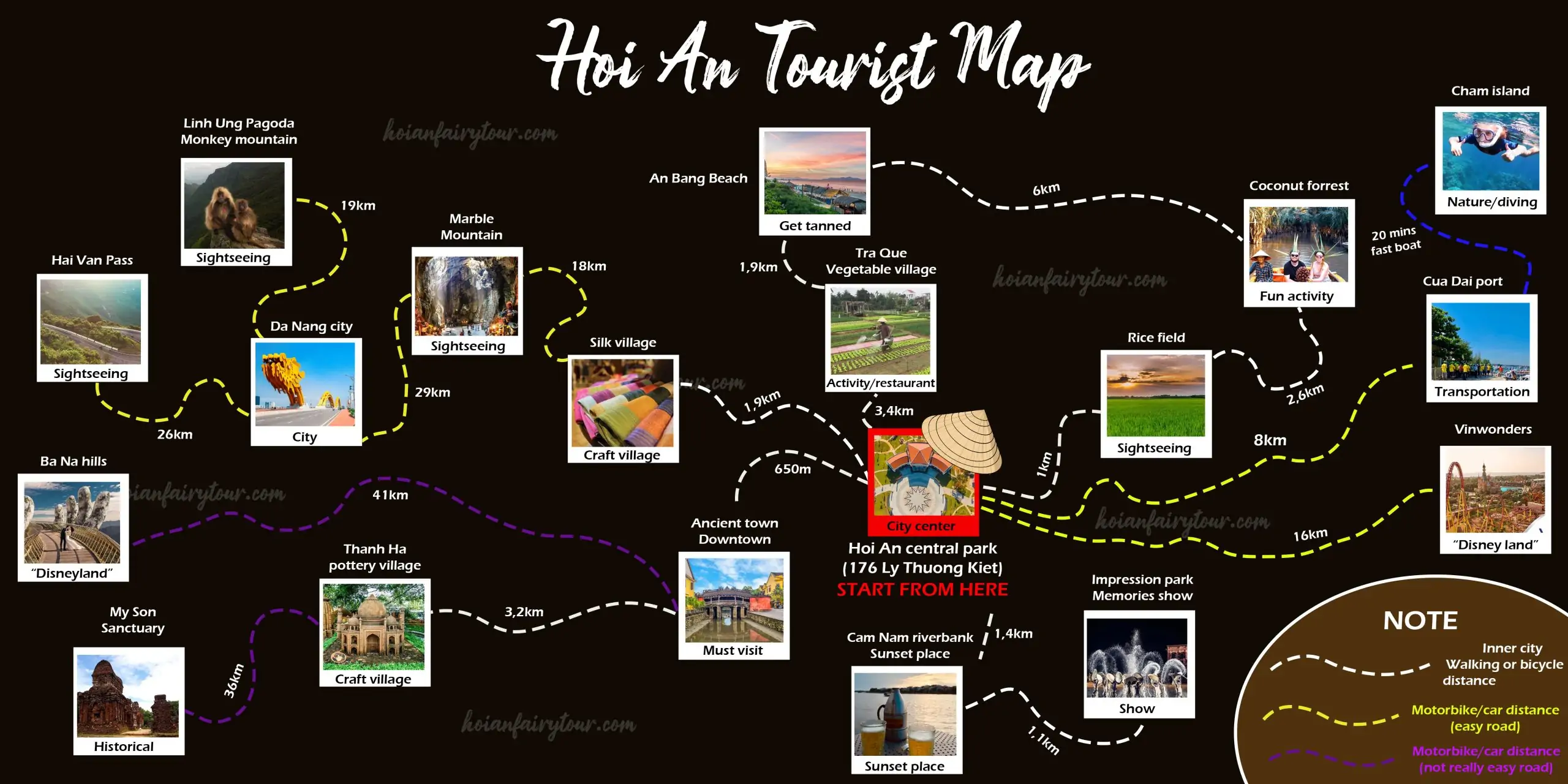


This Hoi An tourist map shows the places most visitors want to see around Hoi An, from the Ancient Town to the Cham Islands, and how far each one is from the central park. I’m Vincent from Hoi An Fairy Tour. I live and work in Hoi An, and I redrew the map so you can zoom in, tap a photo and jump straight to the details of that place. It works on a phone and on a computer.
Distances come from the map and are rounded road distances along the drawn route, so use them for planning and check the traffic on the day.
Interactive Hoi An Tourist Map
Tap or click a photo to see the distance, the best way to get there and a short intro. Press Read details to jump to that place below, and use the Back to the map button at the end of each place to return here. Zoom with the + and − buttons or pinch on your phone, and drag to move the map.
How to Read the Hoi An Tourist Map
| Line | Road | Best for | Notes |
|---|---|---|---|
| White dashed | Inner city | Walk or bicycle | Short distances around the centre |
| Yellow dashed | Easy road | Motorbike or car | Beaches, Cua Dai, VinWonders, Marble Mountains, Da Nang |
| Purple dashed | Not really easy road | Car or tour | My Son and Ba Na Hills, long and winding |
| Blue dashed | Sea | Fast boat | Cua Dai Port to the Cham Islands, about 20 minutes |
Quick Overview: 18 Places on the Hoi An Tourist Map
| Place | Best way | Distance | Details |
|---|---|---|---|
| Hoi An Ancient Town Must visit | Walk or bicycle | 650 m | Read details ↓ |
| Cam Nam Riverbank Sunset place | Walk, bicycle or motorbike | 1.4 km | Read details ↓ |
| Hoi An Memories Show Show | Bicycle, motorbike or taxi | 2.5 km | Read details ↓ |
| Hoi An Rice Fields Sightseeing | Walk, bicycle or motorbike | 1 km | Read details ↓ |
| Hoi An Silk Village Craft village | Bicycle or motorbike | 1.9 km | Read details ↓ |
| Tra Que Vegetable Village Activity / restaurant | Bicycle or motorbike | 3.4 km | Read details ↓ |
| Thanh Ha Pottery Village Craft village | Bicycle, e-bike or motorbike | 3.9 km | Read details ↓ |
| An Bang Beach Get tanned | Bicycle, motorbike or taxi | 5.3 km | Read details ↓ |
| Bay Mau Coconut Forest Fun activity | Motorbike, taxi or bicycle | 3.6 km | Read details ↓ |
| Cua Dai Port Transportation | Taxi or motorbike | 8 km | Read details ↓ |
| Cham Islands Nature / diving | Fast boat (tour or ticket) | +20 min boat | Read details ↓ |
| VinWonders Nam Hoi An Theme park | Taxi or private car | 16 km | Read details ↓ |
| Marble Mountains Sightseeing | Motorbike, taxi or private car | 20 km | Read details ↓ |
| Da Nang City City | Taxi, private car or motorbike | 29 km | Read details ↓ |
| Linh Ung Pagoda, Monkey Mountain Sightseeing | Motorbike or private car | 19 km from Da Nang | Read details ↓ |
| Hai Van Pass Sightseeing | Motorbike, private car or Easy Rider | 26 km from Da Nang | Read details ↓ |
| My Son Sanctuary Historical | Taxi, private car or a tour | 40 km | Read details ↓ |
| Ba Na Hills Golden Bridge | Taxi, private car or a tour | 41 km from Ancient Town | Read details ↓ |

Prefer a picture you can save? The static version of the Hoi An tourist map is on the right. It has the same places and distances as the interactive map above, so it works offline once you have saved it to your phone.
Around the Centre: Places to Walk or Cycle
These places sit within a few kilometres of the central park. White lines on the map mean you can walk or ride a bicycle, and each place works well as a short stop on the same day.
Hoi An Central Park (start point)
Everything on the map is measured from Hoi An central park at 176 Ly Thuong Kiet. It sits between the Ancient Town and the countryside, so it is an easy meeting point for a taxi, a bicycle or a motorbike. If you stay somewhere else, simply add the distance from your hotel to this park.
With Hoi An Fairy Tour: Hoi An private taxi · Motorbike rental
Hoi An Ancient Town
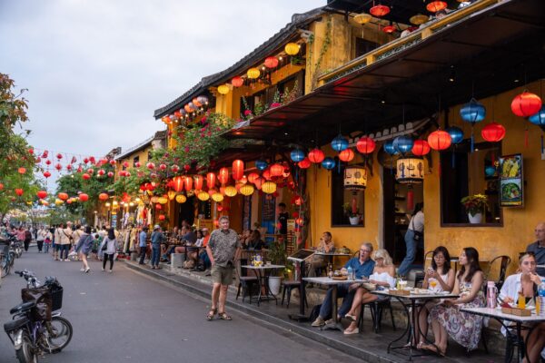
The Ancient Town is the reason most people come to Hoi An: narrow streets of old merchant houses, assembly halls, the Japanese Covered Bridge and a riverfront that fills with lanterns in the evening. It is only 650 m from the start, so walk or bicycle. Most monuments need the Old Town ticket, and our ticket guide explains which five sites are worth choosing. Come early in the morning or after sunset, when it is cooler and quieter.
With Hoi An Fairy Tour: Old Town ticket guide · Self-guided walking tour · Hoi An at night · Boat ride with lantern · Food tour
Cam Nam Riverbank

Cam Nam is the quiet side of the Hoai River, a short ride from the centre. You find small cafes, restaurants and river views, and it is a pleasant place to watch the sun go down without the crowds of the Ancient Town. Fairy Garden Villa is in this area, so it is a neighbourhood we know well.
With Hoi An Fairy Tour: Where to stay in Hoi An · Kayak tour · Boat ride with lantern
Hoi An Memories Show

Hoi An Memories Show is a big outdoor night performance about the history of Hoi An, staged in the Impression theme park. It is 1.1 km beyond Cam Nam Riverbank, so you can combine a sunset at Cam Nam with the show and a late dinner. Seat types and prices differ, and our ticket guide explains each one. If you prefer a smaller indoor show, look at the Teh Dar Show.
With Hoi An Fairy Tour: Hoi An Memories Show ticket · Teh Dar Show · Private taxi
Hoi An Rice Fields

The rice fields start only 1 km from the central park, which makes them the easiest piece of countryside on the map. Water buffalo, farmers and bicycles are a common sight, and the light is best early in the morning or late in the afternoon. The colour changes with the season: bright green while the rice grows and golden before the harvest.
With Hoi An Fairy Tour: Bicycle tour · Vespa tour · Motorbike rental
Hoi An Silk Village

Hoi An Silk Village is 1.9 km from the start and shows how silk goes from cocoon to cloth. You can watch the looms, see the silkworms and buy scarves or small gifts. It is a short stop of about an hour, easy to combine with the rice fields on a bicycle ride.
With Hoi An Fairy Tour: Bicycle tour · Motorbike rental
Tra Que Vegetable Village

Tra Que Vegetable Village is 3.4 km from the start, in the fields between the Ancient Town and An Bang. Farmers grow herbs and vegetables here for the restaurants of Hoi An, and visitors can join a gardening session or a cooking experience. Ride a bicycle through the paddies and continue to An Bang Beach, only 1.9 km further.
With Hoi An Fairy Tour: Bicycle tour · Vespa tour · Cooking class with basket boat ride
Thanh Ha Pottery Village

Thanh Ha is a terracotta craft village on the far side of the Ancient Town, 3.2 km away. Families have made pottery here for centuries, and you can try the wheel yourself in a short class. Go by bicycle or motorbike, and read our village guide for the museum and class details.
With Hoi An Fairy Tour: Thanh Ha village guide · Bicycle tour · Motorbike rental
Beaches, Coconut Forest and Cham Islands
Head east for the sea. Most of these stops are best by motorbike, taxi or bicycle, and the boat to the islands leaves from Cua Dai Port.
An Bang Beach

An Bang is the beach most visitors use, 1.9 km beyond Tra Que Vegetable Village. Beach bars and seafood restaurants line the sand, and sunset and weekends are the busiest times. Cua Dai Beach, further south, has been affected by erosion and repair works, so An Bang is the easier choice for now.
With Hoi An Fairy Tour: Nice beach in Hoi An · Motorbike rental · Private taxi
Bay Mau Coconut Forest

Bay Mau Coconut Forest is a 7-hectare water-coconut forest in Cam Thanh where round basket boats glide through narrow channels. It is 2.6 km from the rice fields on the map and about 6 km from An Bang. Boat spinning and crab fishing are optional extras that you tip the boatman for.
With Hoi An Fairy Tour: Basket boat ride · Cooking class with basket boat ride · Kayak tour
Cua Dai Port

Cua Dai Port is where boats leave for the Cham Islands, 8 km from the start, and the fast boat takes about 20 minutes. The beach next to the port has had repair works in 2026, so treat this place as a pier rather than a swimming spot for now. Arrive early, because boats depend on the weather and the sea.
With Hoi An Fairy Tour: Cham Island snorkeling and diving · Private taxi · Cham Island speed boat tickets and self-guided trip · How to go to Cham Island
Cham Islands
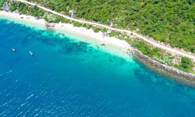
The Cham Islands are a UNESCO biosphere reserve, about 20 minutes by fast boat from Cua Dai Port. The water is clear, snorkeling is the main activity and there are quiet fishing villages on the main island. In windy weather boats sometimes do not run, so keep a spare day in your plan.
With Hoi An Fairy Tour: Diving and snorkeling at Cham Island · Cham Island speed boat tickets and self-guided trip · How to go to Cham Island · Cham Island travel guide
Day Trips by Motorbike or Car
Yellow and purple lines are longer roads. Choose a taxi, a private car or a guided tour for these, and start early.
VinWonders Nam Hoi An

VinWonders Nam Hoi An is a large theme park with rides, a water park and a zoo, 16 km from the start. It is far from the Ancient Town, so a taxi or private car is the easiest choice, especially with children. Plan a full day, bring sun protection and read our ticket guide to choose the right zones.
With Hoi An Fairy Tour: VinWonders ticket guide · Private taxi
Marble Mountains

The Marble Mountains are five limestone-and-marble hills with caves, pagodas and viewpoints. The map shows 18 km from Silk Village, and the hills lie on the road between Hoi An and Da Nang. Am Phu Cave is the most famous part. There are many stairs, so wear shoes with good grip and go in the morning.
With Hoi An Fairy Tour: Marble Mountains half-day tour · Marble Mountains and My Son in 1 day · Da Nang private tour
Da Nang City

Da Nang is Vietnam’s modern coastal city, 29 km on the map. It has the Dragon Bridge, long beaches, Han Market and a strong food scene, and many travellers land at its airport before driving to Hoi An. A private car is the easiest way to see several sights in one day.
With Hoi An Fairy Tour: Da Nang private tour · Da Nang to Hoi An: all options · Airport taxi · Ba Na Hills day tour
Linh Ung Pagoda, Monkey Mountain

Linh Ung Pagoda sits on Son Tra, also called Monkey Mountain, and has the 67 m Lady Buddha statue facing the sea. The map shows 19 km from Da Nang city. Wild monkeys live on the mountain, so keep food and loose items out of sight. Go by motorbike or private car, because the road climbs the peninsula.
With Hoi An Fairy Tour: Marble Mountains tour with Monkey Mountain · Da Nang private tour · Snorkeling in Son Tra
Hai Van Pass
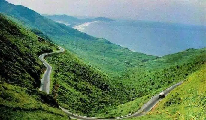
Hai Van Pass is the mountain road between Da Nang and Hue, with sea and coast views on a clear day. The map shows 26 km from Da Nang city. Fog and rain can hide the view, so choose a dry morning. Many people ride it with an Easy Rider, who knows the viewpoints and photo stops.
With Hoi An Fairy Tour: Easy Rider to Hue · Hue day trip · Private taxi
My Son Sanctuary

My Son Sanctuary is a UNESCO-listed group of Cham temples in a green valley. The map shows 36 km from Thanh Ha, so roughly 40 km from the start. Go at sunrise or in the late afternoon to avoid the heat, and use a taxi or a tour instead of a motorbike. Our ticket guide lists the entrance prices.
With Hoi An Fairy Tour: My Son Sanctuary tour · Marble Mountains and My Son in 1 day · Old Town and My Son ticket guide · Private taxi
Ba Na Hills

Ba Na Hills is a hilltop resort near Da Nang, famous for the Golden Bridge held up by two giant stone hands. The map shows 41 km from the Ancient Town and the road is not easy, so a taxi, private car or tour works best. Plan a full day, and go early because the cable car queues grow later in the morning.
With Hoi An Fairy Tour: Ba Na Hills day tour · Ba Na Hills travel guide · Private taxi
Three Easy Ways to Use the Map
A slow day in town: Ancient Town in the morning, lunch, then Cam Nam Riverbank at sunset and the Hoi An Memories Show in the evening. Everything is within 2.5 km, so a bicycle is enough.
Countryside and sea: rice fields, Tra Que Vegetable Village and An Bang Beach, then a basket boat in the coconut forest. It is a relaxed day by bicycle, e-bike or motorbike.
A big day trip: Marble Mountains and Da Nang by private car, or My Son in the morning and the Ancient Town in the evening. Book a car or a tour and leave early. For longer plans, see our Hoi An itinerary and our list of things to do in Hoi An.
Tips for Using the Hoi An Tourist Map
- Start early. Morning is cooler, the roads are quieter and the best light for photos is before 9 am.
- Match the road to your vehicle. White lines are fine by bicycle, yellow lines suit a motorbike or a car, and the purple roads to My Son and Ba Na Hills are easier in a car.
- Check tickets and opening hours. The Ancient Town, My Son, Ba Na Hills and VinWonders each have their own tickets, and the sea decides whether boats to the Cham Islands run.
- Carry your licence and a helmet. If you rent a motorbike, you need a valid licence and insurance, and a helmet is compulsory.
- Plan fewer places. Two or three stops a day is a relaxed pace, and traffic around Da Nang can double the travel time.
Why Plan with Hoi An Fairy Tour
We are a small team based in Hoi An and we know these roads, from the quick ride to the rice fields to the long drive to Ba Na Hills. We only list activities we can arrange ourselves, and our prices are on each page. Hoi An’s Ancient Town and My Son are both UNESCO World Heritage sites, and you can read more about the town on Wikipedia or on the UNESCO page for Hoi An Ancient Town.
How to Book
Choose an activity on our tours and activities page or book a car with our Hoi An private taxi service. If you are not sure which places fit your days, send us a message on WhatsApp (+84 903 532 168) with your dates and the places you picked on the map, and we will suggest a route.
More Hoi An Guides
- Hoi An Itinerary: 1, 2 or 3 days planned day by day
- 25 delightful things to do in Hoi An
- Hoi An UNESCO tickets: Old Town and My Son prices
- Where to stay in Hoi An: 5 areas
- Hoi An at night: 9 things to do after dark
- Da Nang to Hoi An: taxi, Grab, bus and train compared
Frequently Asked Questions
How far is each place from the centre on the Hoi An tourist map?
Ancient Town 650 m, rice fields 1 km, Cam Nam Riverbank 1.4 km, Silk Village 1.9 km, Tra Que 3.4 km, Cua Dai Port 8 km, VinWonders 16 km, Marble Mountains 18 km from Silk Village, Da Nang 29 km, Linh Ung Pagoda 19 km and Hai Van Pass 26 km from Da Nang, My Son 36 km from Thanh Ha and Ba Na Hills 41 km from the Ancient Town.
What is the best way to get around Hoi An?
Walk or ride a bicycle in the centre and the countryside. Use a motorbike for beaches and Cua Dai, and a taxi, private car or tour for VinWonders, Marble Mountains, Da Nang, My Son and Ba Na Hills.
How do I use the interactive Hoi An tourist map?
Tap or click a photo for the distance and a short intro, press Read details to jump to that place on the page, and press Back to the map to return. Use + and − or pinch to zoom.
Can I download the Hoi An tourist map?
Yes. The page includes the static map image with all places and distances. Open the full size and save it to your phone, then turn your phone horizontally to read it.
From Vincent – the Author
If you find this post useful and would like to show your appreciation, you can support me by making a donation via PayPal. Your generosity helps me continue creating helpful content. Thank you!
Paypal Link: [Click here]
HOI AN FAIRY TOUR – HOME – TOURS & ACTIVITIES – TAXI – TRAVEL ESSENTIALS – HOI AN TRAVEL TIPS – ABOUT US